This specific page is the requests page for the Map Workshop. Anyone can make a request for a map to be created or improved. The standard format for making a request is shown below, along with general advice, and should be followed.
Make a request
Show manual procedures
Use the following template when making a new request, replacing the examples with your image(s) and request(s):
<gallery>
 IMAGENAME.EXT|Description of image
 IMAGE#TWO.EXT|2nd image (If there is one)
 ETCETCETC.EXT|Don't request too many at once, though
</gallery>

;Request:
: Details of your request go here… --~~~~
;Graphist opinion(s):
SpBotarchives all sections tagged with {{Section resolved|1=~~~~}} after 7 days and sections whose most recent comment is older than 185 days. For the archive overview, see /Archive. The latest archive is located at /Archive/2025.
Could someone make an svg map of the borders of the Second Polish Republic as of 1929 superimposed on modern European borders? Two versions would be best, one blank and one with locations and names of important cities that either was previously inside Poland (like Lviv and Vilnius) and cities that became a part of Poland after World War II (like Wrocław)? --Colohisto (talk) 05:45, 4 July 2024 (UTC)[reply]
starting October 27, Ukraine will no longer observe summer time (sources in article above). it means that Ukraine will be coloured yellow instead of ochre. technicalities: Russian-occupied regions follow a different separate time zone (UTC+03:00) all year round (fact-check?). see file page for more information. --Juwan (talk) 14:26, 16 July 2024 (UTC)[reply]
Really just the Ifat Sultanate and Ethiopia is needed, but if you could include Ajuran and Warsangali in the corner that'd be grand. There are images on wikicommons of all of these that can be copied. --Kowal2701 (talk) 19:34, 21 July 2024 (UTC)[reply]
Graphist opinion(s)
Map(s) of proposed LaGuardia Airport subway extensions
One or two maps showing both proposed extensions of the BMT Astoria Line to LaGuardia Airport, as illustrated on pages 17 and 18 of this 2022 PDF from the Port Authority. This can be one image showing both alignments or separate images for each. The current Astoria Line should be in this yellow (#fccc0a, PMS 116) while the proposed alignments can be a lighter shade of yellow. --Qzekrom (talk) 01:01, 30 July 2024 (UTC)[reply]
I have extracted only the California portion of the 1968 U.S. presidential election's congressional district map to create a congressional district map for the 1970 California gubernatorial election, but I cannot match the projections. --Dmsu (talk) 07:15, 16 August 2024 (UTC)[reply]
I am short on time right now, but the map needs to be edited to mark the Russian occupied territories of Ukraine as disputed, perhaps with a grey/green stripe pattern. The grey colour may also need to be lightened to #C0C0C0. --Minoa (talk) 13:16, 16 August 2024 (UTC)[reply]
Given this is likely an issue across all theoretically current Russian administrative border maps, it might be best to create a category to put maps needing an update in. CMD (talk) 13:59, 9 December 2024 (UTC)[reply]
The following map could help, but it does not include the stations beyond Pozzuoli Solfatara and includes the station Napoli San Giovanni Barra, which is not part of the "Passante ferrovario di Napoli." –Yeagvr (talk) 19:19, 8 September 2024 (UTC)[reply]
Map of Naples Line 2 which runs on a part of the Passante.
@Yeagvr I thought I was ready with the base map but I see now (your google maps link is not working fully) that Villa Literno is so much further west and norht so I have to extend the map. I didn't check this enough before, so just you know, I'm working on it but have to add to the base map. --please ping me-- Goran tek-en (talk) 13:48, 30 December 2024 (UTC)[reply]
Article(s): over a hundred pages as can be seen on the picture page, for instance pt:TransBrasil
Request
There are several inconsistencies on this map, since the last update is from 2018. I will list them below:
Extended content
VLT Carioca:
line 1 has been expanded to the west, with a new station called "Terminal Intermodal Gentileza";
the branch between Praia Formosa and São Diogo has been cancelled and should be removed;
line 3 entered operation, I'll detail the new stations down below;
BRT Transbrasil: has started operation, going all the way until Terminal Intermodal Gentileza. Please double check stations names as well as the path (the expansion towards downtown has been discarded);
Other than that they've changed their logo, it'd be nice to update on the legend, check their website
BRT Transoceânica: is currently in operation. Should be renamed to "BHLS Transoceânico" and has three different lines, that enter bus corridor between Charitas and their destination, and go towards Niterói downtown;
Bonde de Santa Teresa: has been expanded, southwest until Dois Irmãos, a branch towards Monte Alegre and a small branch towards Muratori, are all operating;
Ônibus expresso: all of them don't exist anymore and should be removed;
Conexão BRT: BRT operator created three regular bus lines similar to previous Ônibus Expresso which could be interesting to show on the map. You can check their details on their website: https://mobi-rio.rio.br/
MetrôRio: the two circles in Estácio station should be a single circle as it is a single station with integration between two lines.
Teleféricos (cable cars): Alemão exists but is still suspended; Providência resumed operating; Rocinha never had a proper project (just politician intention) and therefore should be removed;
Planos inclinados (funiculars): title is missing an "s"; P.I. do Condomínio Equitativa, P.I. Regina Coeli, P.I. do Cemitério São João Batista, Funicular Rio Arte and Monotrilho de Vila Santa Cecília are private and should be removed. All other are currently in operation.
Double check all station names. I will do this homework and edit my comment.
MetrôRio (subway) - they have added suffixes to stations located on neighborhoods with more than one station, indicating the neighborhood, as can be seen on their website. Therefore these stations should be renamed:
Lines 1 / 4, from north to south:
Uruguai should be "Uruguai / Tijuca"
Saens Peña should be "Saens Peña / Tijuca"
São Francisco Xavier should be "São Francisco Xavier / Tijuca"
Afonso Pena should be "Afonso Pena / Tijuca"
Central should be "Central do Brasil / Centro"
Presidente Vargas should be "Saara / Presidente Vargas" (yes, this is an exception to the rule)
Uruguaiana should be "Uruguaiana / Centro"
Carioca should be "Carioca / Centro"
Cinelândia should be "Cinelândia / Centro"
Cardeal Arcoverde should be "Cardeal Arcoverde / Copacabana"
Siqueira Campos should be "Siqueira Campos / Copacabana"
Cantagalo should be "Cantagalo / Copacabana"
General Osório should be "General Osório / Ipanema"
Nossa Senhora da Paz should be "Nossa Senhora da Paz / Ipanema"
Jardim de Alah should be "Jardim de Alah / Leblon"
Jardim Oceânico should be "Jardim Oceânico / Barra da Tijuca"
Line 2, from downtown towards northwest:
Nova América / Del Castilho should be "Del Castilho"
On Pavuna, only the subway station is called "Pavuna"; the SuperVia one is "Pavuna / São João de Meriti"
SuperVia, corrections on the lines, starting from downtown towards the suburbs, on counterclockwise fashion (for more information, check OSM or their website:
Linha Deodoro / Santa Cruz:
Mangueira should be "Mangueira / Jamelão"
Silva Freire is only serviced on Linha Japeri, maybe we could duplicate the line between Deodoro and Central do Brasil to indicate that?
Terminal Deodoro should be "Deodoro"
Regarding "São José de Magalhães Bastos", only the BRT station has that name, the train station name is "Magalhães Bastos"
Mocidade de Padre Miguel should be "Mocidade / Padre Miguel"
Santissimo should be "Santíssimo" (note the "í")
Benjamin do Monte should be "Benjamim do Monte" (note the "m")
Serviço Circular Honório - Deodoro has been deactivated and should be removed from the map
Linha Japeri:
Riardo de Albuquerque should be "Ricardo de Albuquerque"
Linha Belford Roxo:
Cavalcante should be "Cavalcanti"
Pavuna should be "Pavuna / São João de Meriti"
Linha Saracuruna:
Bonsucesso TIM should be "Bonsucesso"
Saracuna should be "Saracuruna"
Linha Vila Inhomirim:
(all correct)
Linha Guapimirim:
missing stop "Santa Dalila" between Parque Estrela and Suruí
missing stop "Santa Guilhermina" between Suruí and Iriri
Parada Capim should be "Jardim Guapimirim"
VLT Carioca
As mentioned above, there is a new branch from Rodoviária to the west, with a new final stop called "Terminal Intermodal Gentileza"
The branch from Praia Formosa to São Diogo has been cancelled and should be removed.
For more details, check OSM as well as their website.
Stop names corrections, on clockwise fashion:
Line 1
José Bonifácio stop was never constructed and should be removed
Cidade do Samba should be "Cidade do Samba Tia Ciata"
Parada dos Navios should be "Parada dos Navios Valongo"
Antônio Carlos should be "Antônio Carlos MAM"
Line 2
Praça XV should be relocated closer to the water, next to the ferry station
Rio Branco should be "Colombo"
Praça Tiradentes should be "Tiradentes"
Itamaraty has been moved to a different position, southwest of the letter "I" on the map (check OSM for proper position); it's name is "Cristiano Ottoni Pequena África"
Central do Brasil should be "Central" (only for VLT / tramway);
Porto dos Cabritos should be "Paulo Malta Rezende"
Freeway should be "Afrânio Costa"
Riveira should be "Riviera"
Pontões/BarraSul should be "Pontões/Barra Sul"
Recreio/Salvador Allende should be separated. The station along the Transoeste line (on the east-west axis) is "Salvador Allende"
Glaucio Gil should be "Gláucio Gil"
Benvindo Novaes should be "Benvindo de Novaes"
Gramado (close to Campo Grande) has been removed.
Transcarioca
Rio II should be "Rio 2"
Pedro Correia should be "Pedro Corrêa"
Fundão should be removed, it is duplicated with "Terminal Fundão / Aroldo Melodia" (the latter is in correct position)
Transolímpica
As mentioned above, "Recreio / Salvador Allende" should be separated; the circle below is "Terminal Recreio"
Catedral de Recreio should be "Catedral do Recreio"
Padre João Chribbin should be "Padre João Cribbin (Marechal Mallet)"
Transbrasil
To start with, the line starts in "Terminal Intermodal Gentileza" so stations Candelária, Presidente Vargas, Sambódromo, Cidade Nova, Leopoldina and Gasômetro should be removed. Other than that, most stations have different names:
Cajú / São Francisco should be "Vasco da Gama"
Parque Vitória should be "Benfica"
Joana Nascimento should be "Hospital de Bonsucesso / CPOR"
Nova Holanda should be "Baixa do Sapateiro"
Darci Vargas should be "Rubens Vaz"
Ramos should be "Piscinão de Ramos"
Escola da Marinha Mercante should be "Marinha Mercante"
Escola da Marinha do Brasil should be "Lobo Júnior"
Brás de Pina should be "Mercado São Sebastião"
the point with no name before Ponto Chique needs to be removed
Ponto Chique should be "Cidade Alta"
the BRT point next to train station Parada de Lucas needs to be removed
Isidro Rocha / Correia Andrade should be "Vigário Geral / Praça Dois"
Manguinhos should be removed
Irajá / Ceasa should be "Irajá"
Coelho Neto should be "Fazenda Botafogo"
Barros Filho should be removed
Carrefour / Guadalupe should be "Jardim Guadalupe"
missing one more stop, "Guadalupe" before Terminal Deodoro
Other than that, next to Transbrasil, there are two bus terminals under construction that you might want to include: "Terminal Missões" (next to Cidade Alta station) and "Terminal Margaridas" (between Vigário Geral / Praça Dois and Irajá).
And the Conexão BRT bus lines, the stops have names and it would be very nice to include them as well. However they were not included on OSM yet and therefore for a non-local would be hard to get stop positions; this could be added on a second moment.
BHLS Transoceânico
There are three lines, all of them start on downtown on "Terminal Rodoviário João Goulart", go on regular bus stops and enter the BHLS corridor that currently exists. I think it'd be good to include the path towards downtown, as well as the path to the neighborhoods outside of the bus corridor, but without including the regular bus stops, only the BHLS corridor stops. You can check routes on OSM:
I can do this but I will create a new map as a svg file, it will be so much easier to update in the future. I also will need your assistance/knowledge in the process of creating it. Request taken by --please ping me-- Goran tek-en (talk) 15:02, 6 November 2024 (UTC)[reply]
1. Yes, that'd be great if possible. I can help translating it to pt-br of course.
2. Yes, those are the five main categories. Your five initial points are correct and are the most important. "Linhas de Ônibus Expresso, Express Rio de Janeiro" are gone, you can remove those altogether. We now have a couple of "Conexão BRT" "BRT connection" lines, but it might be a bit hard to find information about those. I will try to get it with the agency and map it on OpenStreetMap. The other three have a bit of more touristic purpose but are public transport nevertheless. And yes, "BHLS Transoceânico" is a bus corridor on the city of Niterói, which is on the east of Rio de Janeiro metropolitan area, which corresponds to the right part of the map (right side of the bay). It is a bus corridor in part of it's way, with stops that resemble BRT / LRT stops (bigger structure, exclusive right of way) while in other areas it is just a regular bus line (stopping on regular stops / mixed in general transit).--ArlindoPereira (talk) 09:21, 11 November 2024 (UTC)[reply]
@ArlindoPereira Thanks, I'm right now working on creating the base map so it will be a while before I start with the different lines. Very happy you will be available to support me. --please ping me-- Goran tek-en (talk) 14:38, 11 November 2024 (UTC)[reply]
I actually also would need all the stations names as I'm not familiar with all the diacritical symbols, please group them as you have above.
Sorry about the work load for you but it's very difficult when you don't know the language, thanks. I can probably get the names from OSM. --please ping me-- Goran tek-en (talk) 17:34, 12 November 2024 (UTC)[reply]
I have just remembered of "Mapa Metropolitano de Transportes", it was a map made from previous state administration that had all transports. It has been unfortunately dropped by current administration, so it is outdated (do not show new BRT Transbrasil and LRV Line 4) but should give a general idea of the network. There is a copy of it in https://www.tremdedados.com.br/mapa-rio-metropolitano-de-transportes/
An interesting detail of it is that it shows differently free transfers and paid transfers. That is because of our stupid company based fares, you cannot switch from one company to another (say from MetrôRio/subway to SuperVia/trains) without paying a new fare. So it shows as white the transfers that are free (between different lines of same operator) and as black transfers that are paid (between different lines of different operators). I understand that this add a new layer of complexity but it might be interesting to show on the map if you manage to include (but I wouldn't say it would be strictly needed).
Extended content
Sure @Goran tek-en, I will list the OSM relations for all systems and lines:
Line 1, or in portuguese "Linha 1": Uruguai/Tijuca ↔ General Osório/Ipanema
Please notice this line is "intertwined" with Line 4. This means there is no change of trains needed on General Osório/Ipanema, trains go all the way from Uruguai/Tijuca to Jardim Oceânico / Barra da Tijuca. In reality in one way the train is named "Line 1/Line 4" and in the other way around is "Line 4/Line 1". This is due to political reasons (Line 4 was constructed many years after Line 1). They are still shown as two separate lines despite in reality being a single line operation. This means you don't need to mark General Osório/Ipanema a interchange station, just treat it as a regular station within the two lines as their supplied PDF map.
Line 2 / "Linha 2": Pavuna ↔ BotafogoandPavuna ↔ Estácio
Please notice this line has two different operations. During the weekdays, it runs from Pavuna until Botafogo, meaning stations between Central do Brasil / Centro and Botafogo are serviced with Line 1 and Line 2 trains.
On weekends this line is not mixed with Line 1 and finishes operation on Estácio station, in which users can change platforms and take Line 1 trains.
Pavuna → Estácio is missing from OSM. It is basically the same from Pavuna until São Cristóvão, then instead of going to Cidade Nova, it diverges southeast until Estácio station. I will create the relation on OSM soon.
Estácio → Pavuna (idem)
Line 4 / "Linha 4": General Osório/Ipanema ↔ Jardim Oceânico/Barra da Tijuca
They have five lines departing from the same station, Central do Brasil (just as curiosity, something like "Brazil Central Station" back from the old days we use to have long distance trains). Then they have three other lines, that depart from two final stations of two of the following five lines.
The three first stops, Central do Brasil, São Cristóvão and Maracanã act as a hub because on them you can change between all five lines (and to nearby subway stations). The next stop on Saracuruna and Belford Roxo lines, Triagem, is also a transfer station between those two lines.
Deodoro Line / "Ramal Deodoro": Central do Brasil ↔ Deodoro. Is also called "stopper train" because the next two run parallel to it stopping in fewer stations.
Santa Cruz Line / "Ramal Santa Cruz": Central do Brasil ↔ Santa Cruz
Is also called "express line", together with Japeri line, because between Central do Brasil and Deodoro it skips many stops that are served only by the stopper trains. It is possible to switch between Santa Cruz and Japeri lines to/from Deodoro line in all stops between Deodoro and Central do Brasil, except for Silva Freire station, that only serves express trains.
Saracuruna Line / "Ramal Saracuruna": Central do Brasil ↔ Saracuruna
They also show Gramacho as a terminal because they have also a smaller services Central do Brasil ↔ Gramacho and Gramacho ↔ Saracuruna. The line is duplicated all the way from Gramacho to Central do Brasil but from Saracuruna to Gramacho it is a single line. If I recall correctly it operates on weekdays directly from Central do Brasil to Saracuruna without transfer needed in Gramacho and on the weekends it is split in Gramacho and you need to switch trains if you want to go all the way to Saracuruna.
Line 4 / "Linha 4": Praça XV ↔ Terminal Intermodal Gentileza
Praça XV → Terminal Intermodal Gentileza
Terminal Intermodal Gentileza → Praça XV
both are missing OSM relations, I will create them soon. It is very similar to Line 2, changing only the initial/final stop, being Terminal Intermodal Gentileza instead of Praia Formosa.
The base map we can change, this is a part that shows the Metro lines as I have understood it. This is the style I intend to use so see what you think. Please be straight and open with your feedback, thanks.
The only thing I/we can control regarding viewing is that the map works in 100%. So if you need to download it to be sure you view it in 100%, do so but be sure to delete it afterward. Those drafts are copyrighted to me up to the point I upload it to commons --please ping me-- Goran tek-en (talk) 19:06, 13 November 2024 (UTC)[reply]
Hey @Goran tek-en, it is looking great so far! Loved the companies logos together with the line numbers, it looks very much like an "official" map, by that I mean it has very good quality. Understood your point regarding the copyright of non-final version.
Regarding the other map, yes it is not to the scale, looks more like an schematic / line diagram that somewhat adapts to the geography (up to a certain point) than an "actual" map without many distortions.
I just reminded of yet another map / diagram reference you could use to have a general idea of the rail transports in the city: Urban Rail maps: Rio de Janeiro, a large version with full SuperVia coverage and zoomed in downtown. Of course this map is also very schematic (as all curves are 45 degrees) but one thing I find interesting on it is that it highlights tunnel sections with some parenthesis.
Most likely the downtown area would need to be covered with a square to zoom in at some empty point of the map, like they do, in order to keep the geographic scale of the outer edges but also show downtown in detail.
A couple of things I would change, if possible:
Noticed that "Nossa Senhora da Paz" (on line 4) station name is incorrect, but it was also incorrect on OSM, it should be "Nossa Senhora da Paz / Ipanema". I have just fixed the OSM.
If possible, make the line colors more similar to those used by the transport companies. That means green for Line 2 and yellow for Line 4. They use respectively #b6d52a and #ffc500, but of course you can tweak it to be brighter or darker as needed for a good contrast.
I understand that it would be potentially a challenge once you introduce other networks, because for instance SuperVia (train operator) uses green for Ramal Santa Cruz and MOBI-Rio (BRT operator) uses green for Transolímpica. So you might need to tweak the colors a bit for it to have enough contrast to be able to tell the difference. In that sense, I like that Mapa Rio Metropolitano approach for the colors, you might want to pick their hex values because they seem to put some thought into that (I happen to know the original author, that used to work within the previous state administration). To make it easier, I will copy the hex values they've used (of course you are not required to use the exact colors, but still, might be helpful)
Those stations that have dash on their names, there need to be a space before and after, so foo / bar instead of foo/bar
The forest geometry might get too noisy once all lines are in, consider making it's geometry simpler. Also the white bits inside of it - are those rock exposed parts, without trees? They might look like snow.
On the base map, there is a bit of road missing on downtown, there should be a tunnel on that road right of Carioca / Centro until the road north of Saara / Presidente Vargas stations. It looks a bit weird without it.
Lines colors in hex: (colors marked with an asterisk are from lines created after Mapa Rio Metropolitano was published, therefore I picked the color used by their operators; might need some tweak) @Goran tek-en
@ArlindoPereira Quick reply, I always try to use colors so the maps will work as well as possible for people with color deficiency.
I hope we don't have to do an inset for the downtown area but we will see. Agree on the other parts of map editing, also here we have a Map-template that we try to stick to so most of the created maps here have a deegre of similarity, but it's not a must and I will change now and along the line of work. --please ping me-- Goran tek-en (talk) 17:24, 14 November 2024 (UTC)[reply]
@Goran tek-en Yeah, sending both routes just for completeness sake. Indeed for subway, train and BRT it does not matter (other than double checking that indeed both routes are parallel), but it matters for LRV as some sections of their routes are unidirectional.--ArlindoPereira (talk) 09:05, 15 November 2024 (UTC)[reply]
For Del Castilho, the stations are really separate, one needs to exit, go to the street and walk approximately a block between the two stations. They're not connected like Pavuna, São Cristóvão or Maracanã stations. See OSM route.
Spotted a couple of typos:
SuperVia Deodoro (red) line, from downtown towards suburbs (i.e. from east to west):
After Sampaio should be "Engenho Novo"
After Cascadura should be "Madureira"
After Oswaldo Cruz should be "Prefeito Bento Ribeiro"
SuperVia Santa Cruz (green) line:
Santissimo should be "Santíssimo" (diacritic on first i)
Missing station Campo Grande between Augusto Vasconcelos and Benjamim do Monte (OSM relation was wrong, just fixed it)
Benjamin do Monte should be "Benjamim do Monte" (sorry this one was also wrong on OSM, just fixed it)
Inhoaiba should be "Inhoaíba" (diacritic)
Missing station Paciência between Cosmos and Tancredo Neves (OSM relation was wrong, just fixed it, sorry again)
SuperVia Japeri (blue) and Paracambi (light blue) lines: all correct
SuperVia Belford Roxo line:
(Del Castilho as mentioned above)
Thomás Coelho should be "Tomás Coelho"
just on curiosity, this is another example of two stations with similar names - Tomás Coelho on SuperVia, Thomaz Coelho on MetrôRio - that are not connected. In this case they really are very separate, just happen to be on the same neighborhood but over 1km away from each other, and also spelled differently (no idea why).
Missing station Coelho da Rocha between Agostinho Porto and Belford Roxo
SuperVia Saracuruna line:
After Olaria should be "Penha"
SuperVia Vila Inhomirim line: all correct
SuperVia Guapimirim line:
Missing Santa Guilhermina between Suruí and Iriri
After Parada Modelo should be "Parada Bananal"
After Parada Bananal should be "Guapimirim"
One final detail that might be tricky to make it fit: only the subway station is called "Central do Brasil / Centro"; the train station is just "Central do Brasil", without the suffix.--ArlindoPereira (talk) 15:26, 18 November 2024 (UTC)[reply]
Draft transport-3, I have removed most in the background so it will be more easy for you to check the texts. If you need a draft with all in just let me know.
I would like to understand the real purpose and expectations of this map. How much do you want to be fitted, into what degree of details, because it’s impossible to get everything in and so it will still be eligible. Is it to just show an overview or more detailed. Because so far I haven’t found any map with all the different means of transportation in one map and that is probably that it would get too hard to understand, so please try to explain to me, thanks.
For every thing we add I have to change other stuff to make it work so you will have to check everything for every draft, I do understand that will mean more work for you but this is the reality. I also haven’t made the final fixes with all the texts as I have to change all the time, will do that when everything is set.
Just info: Santa Guilhermina, it’s not on the link to OSM and not on the source png but I found it.
For BRT I have two lines TransBrasil and TransConexao, but I can’t find any stops or names for them. The maps I find have too low resolution.
If Boiúna is supposed to be spelled like this you could edit OSM.
@Goran tek-en Thanks again for updating. I will do a full double check on all lines. But first answering your questions:
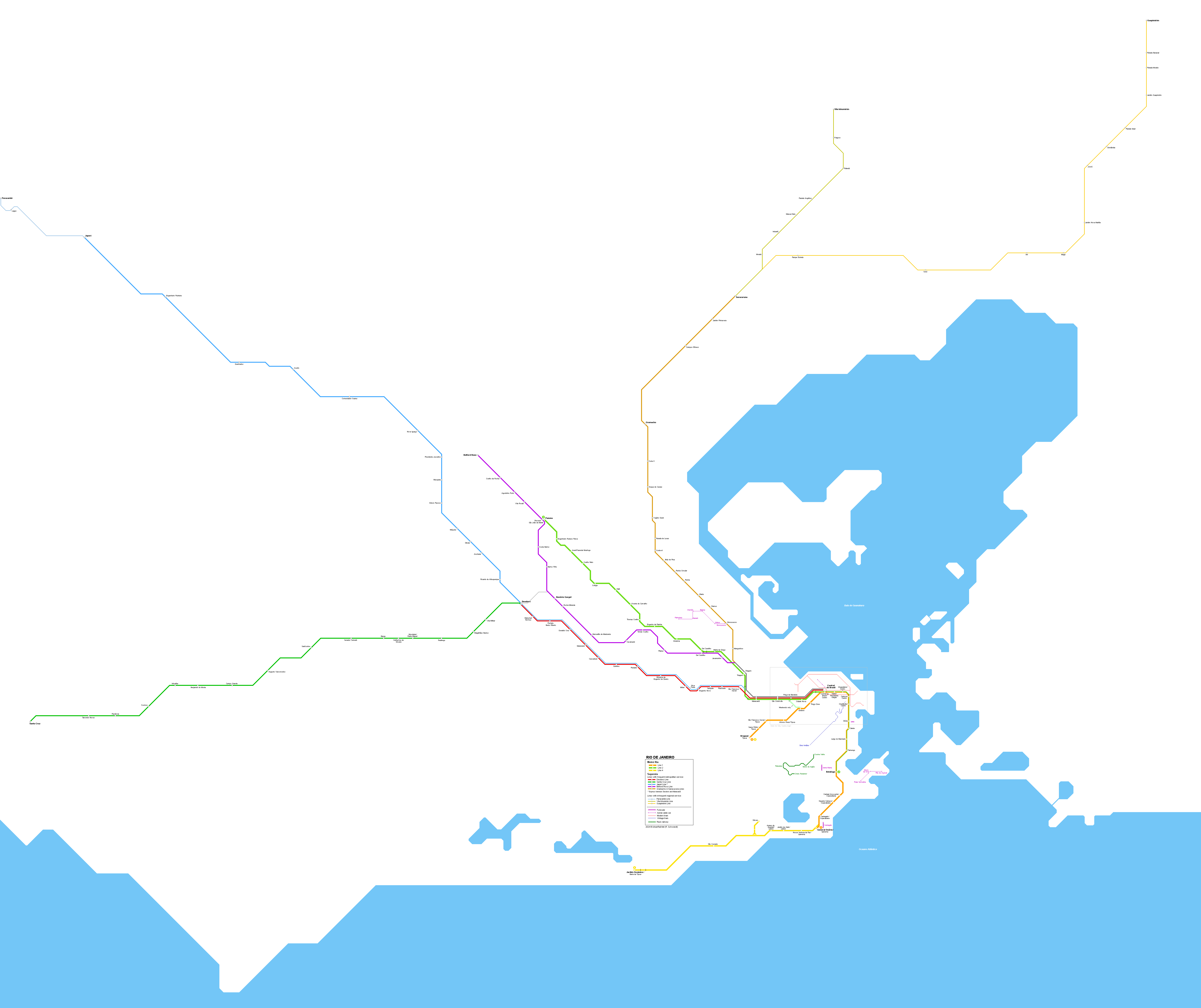
As mentioned on my initial message, the idea is to update File:Public_transport_map_of_Rio_de_Janeiro.png, which is used in hundreds of pages, in multiple languages as a general map of Rio transport. Yes, it is quite of a challenge (thanks again for picking it up!)
Yes I can check always, I mean that's the least I can do. I am looking forward to it.
Sorry about Santa Guilhermina, I will double check OSM relations.
For BRT lines, I will write down the stop names, and also double check them on OSM. There are 4 BRT lines, in the order they were built (I also suggest you use this order on map legend): TransOeste (blue, from south to northwest), TransCarioca (orange, from south to northeast), TransOlímpica (green, from southwest to north) and TransBrasil (red, from west to downtown/east (our downtown is on the center of metropolitan area, by the bay)).
Yes Boiúna has a diacritic. I will double check all stations and update their names, please check the list down below.
I like the idea of depicting terminals as "T (station name)" but I'd add a dot for the abbreviation, thus making "T. (station name)".
But first my observations about draft #3:
BRT logo is outdated. The BRT lines were operated by a private company called "BRT Rio" until 2021, now they're operated by a public operator called "MOBI-Rio". This is their website: https://mobi-rio.rio.br/. I will ask them for a logo for each line and will share with you asap.
MOBI-Rio website has all details, but some stations have wrong names on their website. I will also double check the spelling on Street View imagery to make sure that the list below is correct (and also make sure that OSM is correct). I will mark on the list below in italic when the spelling in reality differs from MOBI-Rio website.
Some BRT stations have "suffixes" written in small print in station names (example), with the name of a closest POI. I think adding them is not needed.
Some BRT stations are Terminals, I'll mark them in bold. They're terminals either because they connect to other modals, to other BRT lines or to an adjacent (regular) bus terminal. In some cases (for instance Salvador Allende) the station itself is not a terminal, but it is adjacent to a terminal. In this case mark the two stations separately with a connection between them.
You added one Conexão BRT line, looks nice to be able to see that connection on the map, but I think that maybe it could be on a thinner line.
BRT stations names:
TransOeste (blue), from east to northwest:
Terminal Jardim Oceânico (connection with subway); Bosque Marapendi; Paulo Malta Rezende; Afrânio Costa; Riviera; Ricardo Marinho; Parque das Rosas; Barra Shopping; Terminal Alvorada (connection with TransCarioca); Bosque da Barra; Novo Leblon; Américas Park; Santa Mônica Jardins; Riomar; Golfe Olímpico; Interlagos; Pedra de Itaúna; Pontões/Barra Sul; Salvador Allende (connection with TransOlímpica); Gelson Fonseca; Guignard; Gláucio Gil; Benvindo de Novaes; Nova Barra; Gilka Machado; Guiomar Novaes; Recreio Shopping; Recanto das Garças; Notre Dame; Dom Bosco; Pontal; (tunnel); Ilha de Guaratiba; CTEx; Embrapa; Terminal Mato Alto; Terminal Magarça; Terminal Pingo d'Água; Vendas de Varanda; Santa Veridiana; Terminal Curral Falso; (from here begins the branch towards Campo Grande, stations on the next bullet point); Cajueiros; Gastão Rangel; General Olímpio; Terminal Santa Cruz
Branch towards Campo Grande, from the branch towards Campo Grande: Cesarão I; Cesarão II; Cesarão III; Vila Paciência; Três Pontes; Cesarinho; 31 de Outubro; Santa Eugênia (connection with SuperVia); Júlia Miguel; Parque de São Paulo; Cosmos; Icurana; Vilar Carioca; Inhoaíba; Ana Gonzaga; São Jorge; Pina Rangel; (from here, it starts to be one-way loop) Parque Esperança; Cândido Magalhães; Terminal Campo Grande; (and returning from it) Prefeito Alim Pedro.
TransCarioca (orange), from south to northeast:
Terminal Alvorada; Lourenço Jorge; Aeroporto Jacarepaguá; Via Parque; Centro Metropolitano; Rede Sarah; Rio 2; (after Rio 2 it branches northwest to continue main path, and also continues forward west) Pedro Corrêa; Curicica; Praça do Bandolim; Arroio Pavuna; Vila Sapê; Recanto das Palmeiras; Divina Providência; Santa Efigênia; Merck; André Rocha; Terminal Taquara; Aracy Cabral; Terminal Tanque (no need to the full name IMO); (checked names until this point) Ipase; Praça Seca; Capitão Menezes; Pinto Teles; Campinho; Terminal Paulo da Portela; Madureira; Mercadão; Otaviano; Vila Queiroz; Vaz Lobo; Marambaia; Vicente de Carvalho; Vila Kosmos; Pedro Taques; Praça do Carmo; Guaporé; Pastor José Santos; (here a small oneway segment, going northeast is Penha 2, going southwest is Penha 1); Ibiapina; Olaria; Cardoso de Moraes; Santa Luzia; Maré; Terminal Fundão; Galeão Tom Jobim.
(continuing the branch after Rio 2 going west); Parque Olímpico; Terminal Centro Olímpico.
Yes it is a mean of transport, it's just that in my mind it feels a bit weird that they have so much prominence, but that might be just premature optimization.
Good catch, "Pontões / Barra Sul".
Parque Esperança. In general, all words in station names should be with the first letter capitalized, except when it's an article or connecting word such as "Bosque da Barra" (literally "Barra's Forest" - the word "da" is like the "'s" in English). Sometimes the article is merged to the word, such as "Pingo d'Água" (and not "Pingo D'água").
I need to finish the BRT station name cleaning, I was editing on OSM but that is taking too long and I don't want to keep you waiting, so I will finish the list above asap (and only fix on OSM later).
Amazing page! Seems to be a good reference. It's similar to that Urban Railways website, but without restricting itself to railways only.
Nice. Would probably be an interesting challenge, in terms of design.
Considerations about Draft 4:
Looking very nice! The final result is going to be absolutely wonderful :)))
Loved the "ribbon" solution for the SuperVia parallel lines, and specially the attention of leaving a small gap between that ribbon and the MetrôRio line.
Also liked very much the indication in black for paid transfers, vs. white for free transfers.
I know it'd be very challenging to name the VLT Carioca stations downtown, but I wouldn't put their names to the bottom. It might be messier, but might be better to put their names only to the top; eventually those legend "balloons" could have the same spacing as their lines below have.
Maybe it'd be better to drop the suffixes for the stations next to each other and have that information as an asterisk on their names? So having the same "cluster" be called "Central do Brasil*", or "Carioca*", or "Cinelândia*" and explain with a small print on the legend that the subway stations have the suffixes.
For corrections, with the exception of stations names typos (I'll ignore those for now as I still need to give you a full list of station names for BRT):
VLT is missing the branch between Rodoviária and Terminal Intermodal Gentileza. Nowadays only Line 2 (green) go to Praia Formosa; Lines 1 (blue) and 4 (orange) go to Gentileza. See https://www.vltrio.com.br/#/mapa-turistico
Missing connection indications:
Triagem (paid between MetrôRio and SuperVia)
Pavuna (paid between MetrôRio and SuperVia)
Vicente de Carvalho (paid between MetrôRio and BRT)
Deodoro (free between SuperVia lines; free between BRT lines, including Conexão; paid between those two clusters)
Magalhães Bastos (paid between SuperVia and BRT)
Vila Militar (paid between SuperVia and BRT)
Madureira (paid between SuperVia and BRT)
Missing two Conexão BRT lines (only one has been included so far)
For these Conexão BRT lines, probably might be an overkill to include intermediate stops as those are simple bus stops, often without any infrastructure other than a simple post with a sign. That's why I also think it might be better to list it as a thinner line, otherwise it looks like a train line or something of more importance.
@Goran tek-en Not really other than a few gigs, I'm just a public transport enthusiast. I like hanging around communities such as SkyScraperCity and local ones. Most of my Wikipedia edits in portuguese are related to PT :)
This logo you shared is of VLT Carioca, i.e. the operator for LRV in downtown. The other one I uploaded is of Mobi-RIO, i.e. the BRT / rapid bus network operator.
Coolio.
Those are the three Conexão BRT lines, you have included line 67 so far:
Also it should be named "Conexão BRT", not "Transconexão".
It looks fantastic. Once again I will ignore the station names (I need to finish that list above asap) and focus on everything else:
Loved the BRT logo with the names "pills" below, looks very clean.
BRT Transoeste legend has a typo (Transoeste, not Transoesta).
Also liked very much the differentiation between BRT (clean line), Train (line with inner white) and Subway (line with inner black).
I suppose you want to get it completed before tackling the other modes of transport, such as ferries etc.
VLT / LRV on downtown looks neat. Do you consider an inset to display it with bigger detail, even though it is readable currently?
Stop "Equador", liked how you made it fit in two lines, but the syllable separation is "E-qua-dor" so it'd be better to split it as "Equa-dor" instead of "Equ-ador".
BRT, a couple of details:
There needs to be a connection between TransCarioca and TransOlímpica between stops Rio 2 and Parque Olímpico (south-center of map, above that lake). You can make it green.
Reviewing that source you shared (Metro Route Atlas) and it seems I have forgotten completely about Corredor Metropolitano Alameda São Boaventura (right part of the map, above TransOceânica). It is a bus corridor with stops that has names, similar to TransOceânica. I will double check if it is mapped on OSM and ping you.--ArlindoPereira (talk) 12:44, 2 December 2024 (UTC)[reply]
Corredor Metropolitano Alameda São Boaventura is a bus corridor in Niterói, right side of the map. Several bus lines run on it, on regular streets, and in this specific street they have a dedicated bus corridor. It is similar to BHLS Transoceânico. Stops are called "XXX A" and "XXX B", being A the bus stop towards east and B the stop towards west. On the map you can have both stops simply as "XXX", with the coordinate as the mean as the two stops. Map: https://www.openstreetmap.org/#map=16/-22.88118/-43.09091
Yeah I think it is pretty good. Though as some areas are empty, I think an inset for downtown could be useful, as it can be a bit hard to read, and some smaller modals still need to be added, such as the gondola between Central and Gamboa.
No logo. Also no specific color AFAIK, I guess you could pick blue as that's what they use in the signs: Street View, or just any other color that would make it easier to be differentiated on the legend.
Yes, one stop for any XA XB, named X.
No logo unfortunately. For specific color, I guess it would make sense either orange (as used on the stops "ribbons") or light green / lime (the vehicles colors). Here you can see some pictures: Niterói city website
Regarding the draft
Oooh it is looking so nice :))))
Loved how you shrinked the SuperVia lines to finish at Central do Brasil. Good solution :)
I think it might make sense to add some paid connections to very close stations, such as Santa Cruz (train and BRT) and Paciência/Santa Eugênia (train and BRT). In both cases user just has to cross a street.
Some considerations about Conexão BRT lines:
They look great in yellow, I think it is the first time that shows them mixed with other transports :)
The final stops names can be supressed as they stop on the terminals, together with the BRT lines. This means specifically:
Line 28, no need for "Curral Falso - 28" and "Pingo d'Água - 28", leave only Terminal Curral Falso and Terminal Pingo d'Água respectively
A small detail: the stop Jardim Guaratiba is a bit to the side but that's temporary due to some road works. You can make the line straight and move the stop in horizontal axis so it doesn't detour to the parallel street.
Line 68, similarly no need for "Terminal Deodoro - 68", just list it as "Terminal Deodoro", like you did in Campo Grande
BRT:
TransOeste:
the branch towards Campo Grande, is missing one-way arrows (east bound from Pina Rangel to Campo Grande; west bound from Campo Grande to Pina Rangel).
TransCarioca:
In Madureira it needs some adjustments. The situation there is this: the rail system runs east-west and the BRT crosses it south-north, on a viaduct that runs above the train station. But there are two BRT stations, one named Terminal Paulo da Portela that is south of the train station (and do not cross the viaduct), and one above, on the viaduct, named Madureira / Manaceia. There is free integration between the two bus terminals and paid integration to the railway. OpenStreetMap / Google Maps
Also Penha station needs to be split between stops Penha 1 and Penha 2, with a small one-way segments around it. OpenStreetMapGoogle Maps
I guess I can start reviewing stop names, at least for the rail systems. This means we need to correct these typos:
MetrôRio: all correct
VLT Carioca
Some stations are missing suffixes: Santa Rita Pretos Novos, Camerino Rosas Negras, Cristiano Ottoni Pequena África, Parada dos Navios Valongo
Because it is a vectorial map, maybe having smaller legends for the stops? Because of all the arrows, it is a bit unreadable. Or maybe only the final stops names, and then on the inset the full detail.
SuperVia:
Ramal Deodoro, from east to west:
Missing stop "São Francisco Xavier" between Mangueira / Jamelão and Riachuelo
Maybe Prefeito Bento Ribeiro as a bit crowded? Try breaking the line after Prefeito. If you need to abbreviate, you could use "Pref. Bento Ribeiro"
"Marechal Hermes" has a typo
"Pill" with the name needs to be "Deodoro" and not "DeoDoro"
Ramal Santa Cruz, from east to west:
Maybe move the legend of station "Tancredo Neves" a bit to the left? It looks a bit like the rail station name is "Cesarinho" (the closes BRT station).
Other than that, all correct.
Ramal Japeri and Ramal Paracambi, Ramal Belford Roxo, Ramal Vila Inhomirim: all correct
Ramal Saracuruna, from south to north:
Manguinhos syllable separation is Man-gui-nhos, so you can split it as "Mangui-nhos" if needed, though I think it would probably fit if you move the legend slightly down.
Typo on "Penha"
Ramal Guapimirim, from southwest to northeast:
Parada Santa Dalila can just be "Santa Dalila". (I'm not sure why some stops keep the word "Parada" (lit. Stop) and other doesn't, but still. Street View vs Street View)
BRT TransOeste: Terminal Mato Alto, Parque de São Paulo
Station Gramado has been supressed, this one slipped while I was editing. Just removed it from OSM. Street View
Terminal Alvorada; Lourenço Jorge; Aeroporto Jacarepaguá; Via Parque; Centro Metropolitano; Rede Sarah; Rio 2; (after Rio 2 it branches northwest to continue main path, and also continues forward west) Pedro Corrêa; (here you can also make a green path from nearby Asa Branca to Curicica, the busways are connected to each other in this point); Curicica; Praça do Bandolim; Arroio Pavuna; Vila Sapê; Recanto das Palmeiras; Divina Providência; Santa Efigênia; Merck; André Rocha; Terminal Taquara; Aracy Cabral; Terminal Tanque - Mestre Candeia; Ipase (instead of IPASE); Praça Seca; Capitão Menezes; Pinto Teles; Campinho; (small branch to) Terminal Paulo da Portela; (main branch continues to) Madureira Manaceia; Mercadão (only train station is called Mercadão de Madureira); Otaviano; Vila Queiroz; Vaz Lobo; Marambaia; Vicente de Carvalho; Vila Kosmos; Pedro Taques; Praça do Carmo; Guaporé; Pastor José Santos; (here a small oneway segment, going northeast is Penha 2, going southwest is Penha 1); Ibiapina; Olaria (paid connection to Olaria train station); (viaduct over train); Cardoso de Moraes; Santa Luzia; (viaduct over Avenida Brasil); Maré; Terminal Aroldo Melodia; Galeão Tom Jobim II; Galeão Tom Jobim I.
I think there is some detail about the final airport stations (if it only stops in one of them one way etc.), I'll get the details and update here.
(continuing the branch after Rio 2 going west); Parque Olímpico; Terminal Centro Olímpico.
TransOlímpica (green), from southwest to north:
Terminal Recreio (free connection to Salvador Allende); Catedral do Recreio; Tapebuias; Ilha Pura; Olof Palme; Riocentro; (branch towards east: Terminal Centro Olímpico; Parque Olímpico and connecting to TransCarioca); Morro do Outeiro (free connection to T. Centro Olímpico); Minha Praia; Asa Branca; (small branch going east connecting to TransCarioca again); Leila Diniz; Ventura; Colônia; Outeiro Santo; Boiúna; Marechal Fontenelle; (small branch going east towards Terminal Sulacap); Padre João Cribbin; Magalhães Bastos; Vila Militar; Terminal Deodoro
TransBrasil (red), from west to east:
Terminal Gentileza; INTO; (Caju station is closed, no plans to open, you can remove it / hide it for now); Vasco da Gama; Benfica; Fiocruz; Hospital de Bonsucesso / CPOR; Baixa do Sapateiro; Rubens Vaz; Piscinão de Ramos; Marinha Mercante; Lobo Júnior; Mercado São Sebastião; (small branch going north to Terminal Missões, but it is still under construction, so you don't need to include it for now); Cidade Alta; Vigário Geral / Praça Dois (on the line diagram inside the bus it is listed as this, but the street sign says "Vigário Geral (Praça Dois)" - Street View); (small branch going north to Terminal Margaridas, but it is still under construction, so you don't need to include it for now); Ceasa / Irajá (though sign says only "Irajá" - Street View); Fazenda Botafogo; Jardim Guadalupe; Guadalupe; Terminal Deodoro.
I will wait to try the inset until everything else is set.
VLT Carioca. Will wait with that until everything else is set and we test inset.
Manguinhos. That word is left anchored (it will grove to the right) and when svg is turned into png and especially in thumbnails texts can extend more in the png than what it is in the svg (or the png drafts you see). This has to do with the different libraries wikimedia uses for those functions, so if the svg is viewed somewhere else texts might grow differently. I always want some extra space for the texts in the svg for this reason so I will keep it on two lines.
TransCarioca. “make a green path from nearby Asa Branca to Curicica”, on the pdf I found and the other we have the orange line splits just after Curicica and then follows the green all the way down to Terminal Recreio. Is that what you want?
TransBrasil. Can’t find the following on OSM so I can’t find the positions, can you fix coordinates?
Vasco da Gama; Baixa do Sapateiro; Rubens Vaz; Piscinão de Ramos; Fazenda Botafogo; Jardim Guadalupe; Guadalupe.
I think you should have an extra look at Deodoro, I don’t think I got it right with which is a terminal, connecting to which…
TransCarioca and TransOlímpica are a bit intertwined in this section. This means that there are services that start at Terminal Recreio and go to Madureira, while there are services that start at Alvorada and go to Sulacap, for instance. I don't think we necessarily need to duplicate as the other maps do, because we don't map the dozens of different services, rather the corridor itself. Thus, a small line (either orange or green, or dashed with the two colors) between the "corners" close to Asa Branca and Curicica would suffice IMHO. OpenStreetMap, the green dashed lines are the bus corridors.
Yeah, TransBrasil is a bit broken on OSM. Need some effort to fix. Fixing on OSM while I type this comment:
@Goran tek-en just realized I missed the initial bus station for Niterói public transport: Terminal João Goulart: OSM. Mark as paid connection to Arariboia ferry station. On the east-west axis, the bus corridor from Alameda São Boaventura continues going west on Avenida Feliciano Sodré, then reaching the terminus on non-dedicated lanes via Av. Visconde do Rio Branco, thus with an inverted L shape (maybe we could try a thinner line to this vertical segment?)
The same arrangement of thin line (to represent major bus connection, but without a dedicated bus corridor) could be used to connect the terminal to Charitas. (i.e. TransOceânica lines OC1, OC2 and OC3).
I'm not so happy with having thinner lines, It can be very hard to see the differens especially for people who doesn't have good eyesight. If you look at TRANSBRASIL I have added below the red line, we can do this (or something similar) to the lines where there is a dedicated bus lane instead?
I didn't understand if you wanted me to add the three TransOceânica lines?
I think it is now very solid, just need to the smaller modes of transportation. I know historic tram might be hard because it will be directly under the legend for subway stations (Central do Brasil / Centro, Saara / Presidente Vargas and Uruguaiana / Centro). Do you feel it's time to work on the legend already? Or only after adding all modes?
Fair enough, no thinner lines. Didn't like the dashed pattern on TransBrasil, that specific pattern leads me to think that it is a train. Let's keep it without any differentiation.
(About 3 TransOceânica lines) Nope, just mentioned them so you can see that they start at Terminal João Goulart and go through regular streets, enter TransOceânica bus lanes, then exit through regular streets on the other side. But that would just pollute the map, let's leave that not connected.
Got info on how Galeão stops are operated on TransCarioca: after Aroldo Melodia, bus goes first to Galeão 2, then to Galeão 1, then returns directly to Aroldo Melodia. So maybe we could add some oneway arrows (facing north) to the semi-circles? Though the semi-circles could potentially just add confusion because instead of taking the left and driving the semi-circle clockwise (i.e. going north) it enters from the north and drive on the semi-circle counterclockwise. Anyway just thinking out loudly, such level detail is most likely not relevant enough to be included on the map.
On TransBrasil, Terminal Margaridas needs to be hidden (or if you want a light / gray pattern to indicate it is under construction, that could be a valid option as well).
On TransOeste, it is missing the free connection indication on Terminal Curral Falso, on Terminal Pingo d'Água and on Campo Grande. Oh btw just realized Campo Grande also needs to be a Terminal: Terminal Campo Grande.
Having reserved lanes is the rule for everything we have included, in all bus corridors, with very minor exceptions. So I don't think we need to have this differentiation at all.
@Goran tek-en I think the next step is to add other modes of transportation, which are either more "local", or touristic, or both. More or less in order of importance, those would be:
Corcovado rack railway (touristic train to access the Corcovado mountain, with the famous Christ the Redeemer statue) - OSM
Santa Teresa (historic) tram, from Downtown to Santa Teresa neighborhood, crossing the Lapa Aqueduct on top. This one is both relevant as local as touristic, because residents of Santa Teresa neighborhood can ride it for free, and actually use it as a local mode of transportation, while everyone else pays tourist tickets. It has a single initial station, a couple of major stops along the way and several "bus stops", that are simple stops only with a pole sign, without any specific name, where the tram would only stop by request. OSM
This one is currently being expanded, a branch toward Largo das Neves, and a continuation of main branch towards Silvestre, where it will meet the Corcovado rack railway on a currently deactivated station.
OSM is a bit wrong, it has only the initial stop. It's a total of 6 stations, on 3 different segments of funicular climbing with different degrees of inclination. A friend of mine recorded a couple of videos on it, I will edit OSM to fix it, and will let you know once it's ready.
For all of those transports with numbered stops, as well as the ones with named stops, I don't think it is super relevant to mention the stops name, i.e. for this list only include names for stops for Corcovado rack railway and Santa Teresa tram which are longer anyway. For Sugar Loaf aerialcar, I think it would make sense to instead name the "localities", so showing "Praia Vermelha" for Station 1, "Morro da Urca" for stations 2 + 3 and "Pão de Açúcar" for station 4.--ArlindoPereira (talk) 14:00, 6 December 2024 (UTC)[reply]
Looking good. I would pick different colors for the funiculars, the historic tram and the rack railway. I suggest yellow for the historic tram (as the trams are painted yellow, please check Wikipedia article) and red for the rack railway (idem). The funiculars I think the color you chose is good because it already differentiates them.
Sugar Loaf aerial car is an aerial car system with two lines / four stations. There is one line from Praia Vermelha ("the ground") to Morro da Urca, the smaller hill of the two hills that compose Sugar Loaf. Then there is another station in Morro da Urca towards Pão de Açúcar (the bigger hill). Officially the stations are numbered 1 to 4, but I think you should only have a single legend as "Sugar Loaf aerialcar" / "Bondinho do Pão de Açúcar".
It's missing the cable car in Downtown. I think it will be quite hard to list it without an inset, specially because it's final station, Gamboa, does not connect to VLT stop Gamboa, but to station Providência. Yeah. https://www.openstreetmap.org/relation/6048549
One option we could try is to remove all VLT stops names from downtown, leaving only those on the ends of the lines (so keeping Gentileza, Praia Formosa, Praça XV and Santos Dumont) and only including the names on the inset.
For logos:
Historic tram: I don't know why but Rio de Janeiro state government removed the Bonde de Santa Teresa logo from their website, but Wayback Machine has a copy (on the footer) - direct link
Rack railway: Trem do Corcovado website - direct link (the one on the left).
I would like to test another thing first for those touristic/local transportation. We already have a lot of colors and it will be harder and harder for every one with color deficiencies. We have some kind of structure with metro and trains having a white or black line within their lines and all the buses have solid colors. So in this draft I would like to try to have the same color but varied “patterns” to distinguish them.
I also think we will need insets, I’m also thinking about if we could have some for the really short touristic/local transportation, just as it won’t be too messy, we will see.
Santa Teresa. Is there no station at the end?
”Gamboa, does not connect to VLT stop Gamboa, but to station Providência.” Is that correct should it not be “Gamboa, does not connect to VLT stop Providência, but to station Gamboa” as it is on OSM?
Logos. They are all png’s and I don’t think we would be allowed to copy and transfer them to svg, shall we just leave them out for now.
I still haven't made the texts as visible as they can, will do that when all is #fixed#.
The styles look nice. Liked specially the dashed one for the rack railway and the dotted one for the aerialway.
Though I think that for the funiculars and the aerialway, it might make no sense to list the stops name, but rather the funicular or aerial car name. Listing station 1, 2, 3, 4, 5 do not communicate much, I guess.
Santa Teresa has no big station on the SW end, but some relevant stops with names. Listing below from NE to SW, after those you already have included:
It is a bit confusing. Please open this OSM link while reading my description. You can see that the aerial car N station is Gamboa, and it is very close to a VLT stop, however that stop name is Providência. There is also a VLT stop called Gamboa, to the west, but the one closer to Gamboa aerial car station is Providência. Quite confusing, and challenging to add legends. Hence, on a low level scale, it might make sense to label only the aerial car itself as "Teleférico da Providência" / "Providência Cable Car" and not the individual stations, and leave those details only for the inset.
funiculars and the aerialway. Which would be the names to put out then? Or we save those for the insets.
So in a way the OSM (wikipedia also) is “wrong” and should be renamed… But it’s really confusing to have two names for the same station so either we put out both or pick one.
The name is too long for this Cable car so I will leave it out here.
Funiculars and Cable cars names. You could use the full name in English or Portuguese, or the "short version", in bold.
Bondinho do Pão de Açúcar / Sugar Loaf Cable Car
Teleférico da Providência / Providência Cable Car
Plano Inclinado do Outeiro da Glória / Outeiro da Glória Funicular
Plano Inclinado do Santa Marta / Santa Marta Funicular
Plano Inclinado do Pavão-Pavãozinho / Pavão-Pavãozinho Funicular
Plano Inclinado da Igreja da Penha / Penha Church Funicular
This one has a very long official name "Plano Inclinado Padre Laércio Dias de Moura", paying tribute to a deceased priest but no one really uses that name.
Plano Inclinado da Igreja da Penna / Penna Church Funicular
This one also has a very long official name "Plano Inclinado Monsenhor José Carlos Moreira" and their two stops have also mouthful names, but no one uses those names.
Yeah, another reason to keep their names out of the main map and only use on the insets. But only for the cable cars; I'd say that the funicular stops names are irrelevant (some even don't have names, only numbers).
Penha Funicular is missing some segments. It is comprised of three different funicular ways in succession: 1, 2, 3.
Some minor corrections on BRT:
TransCarioca
Next to Penha Funicular, BRT station Ibiapina is split in a wrong way, the syllable separation would be I-bi-a-pi-na. So if you need to break it, choose Ibia-pina and not Ibiap-ina.
@Goran tek-en looks really nice. I'd change the legend of Historical tram to Santa Teresa tram (it is historical, but that's more of a description than of a name), and similarly the other ones. Other than that it's very solid. --ArlindoPereira (talk) 14:14, 18 December 2024 (UTC)[reply]
@Goran tek-en asked some friends in a public transport group to take a look on the current draft, here's some feedback from the community, that I didn't spot:
There's a typo on BRT TransOeste legend, close to Line 4 subway (it is written Transoesta)
On BRT TransBrasil, the section near station INTO, it is mapped as a binary, but in reality there's no such separation (both directions are on the same way).
There is an interaction on BRT TransBrasil with BRT TransCarioca, that is similar to what happens with BRT TransCarioca and BRT TransOlímpica (that small branch near stations Curicica and Asa Branca). There is a viaduct from BRT TransBrasil, that starts between stations Rubens Vaz and Baixa do Sapateiro, and lands on TransCarioca close to station Santa Luzia. You can map it as a small branch of BRT TransBrasil, thus with red color. https://www.openstreetmap.org/way/578218039 --ArlindoPereira (talk) 17:53, 19 December 2024 (UTC)[reply]
Hi @Goran tek-en, it looks really nice with the insets. First, replying your questions:
Yes, Cristiano Ottoni Pequena África has stops from 3 VLT lines.
Path towards Terminal Intermodal Gentileza looks correct.
No double stations on Praia Formosa. There is a second platform but that is not open to public service, it is just extended to store trams that are waiting for next trip.
No, the ferry to Praia da Bica is not official and should probably be removed from OSM at some point.
On TransBrasil, you need to deduplicate that segment near INTO station, as it is not a binary. The same applies on the inset.
On Praça XV / ferry station, I don't think we need to differentiate the 4 piers / embarkment points. It can be a single station for all 4 ferries, connected to the single station for VLT.
Remarks about Inset 1 (downtown):
There's a typo on subway station Saara / Presidente bVargas
On Uruguaiana / Centro, syllable separation should is U-ru-guai-a-na, so to break in two lines, it should be "Uruguai-(line-break)ana/Centro". Though by the looks of it, it probably fits as "Uruguaiana/(line-break)Centro".
Similarly, on VLT station Providência, syllable separation is Pro-vi-dên-cia.
On Santa Teresa (historical) tram:
Curvelo should be Largo do Curvelo
Largo do Guimarães should be Largo dos Guimarães
Inset 2:
On Corcovado rack railway, there's a bit of controversy on the final station name. Both OSM and Wikipedia mark it as "Cristo Redentor", though doing a bit of research, it seems that the station name in reality is "Corcovado", according to this photo it reads "Estação Corcovado" or "Corcovado station". I will fix OSM accordingly.
Aerialway on Sugar Loaf mountain could have the stations named according to their "locality", i.e. station 1 (south west) could be "Praia Vermelha", station 2 + 3 could be both "Morro da Urca" and station 4 could be "Pão de Açúcar".
On subway station General Osório / Ipanema, you can make both lines connect to the same station. The situation over there is: there are two stations / platforms underground, the one on the south is currently not in use; the one on the north is used by trains on "line 1 interconnected to line 4". Stupid naming, in reality they are the same line.
Inset 3:
It is missing one way arrows around Penha 1 and Penha 2 (arrows going east-west around Penha 1 and west-east around Penha 2).
There could also be paid connection between train station Penha and BRT station Penha 1.
On Funicular:
"Plano Inclinado Padre Laércio Dias de Moura" is a mouthful. Yes it is the official name but no one calls it by that, including official signage. Please name it "Bondinho da Penha".
Please connect the south station of the "vertical segment" with the east station of the "horizontal segment" as free integration, as they're basically the same "station".--ArlindoPereira (talk) 23:45, 28 December 2024 (UTC)[reply]
Hi @Goran tek-en, hope you had a nice new year holiday :)
For TransBrasil / INTO, you can remove the northeast segment/station and keep the southwest one.
All other details look perfect to me. I will ask for some friends help to double check everything, but all looks correct.
While typing, noticed a couple of small details:
in BRT TransBrasil, Terminal Missões needs to be in gray as it is still under construction.
In Corcovado rack railway, final station name is "Corcovado" and not "Estação Corcovado" ("Estação" = "Station").
Regarding the legend:
I don't think it's a problem that the names eventually are repeated in logos and in text boxes.
BRT could be named "BRT MobiRIO"
Please order them in a-z order, so TransBrasil, TransCarioca, TransOeste and TransOlímpica.
Also I think it makes sense to order the transport types then in order of importance / "trunkness" (is that even a word?) so on the left I'd order as: subway, suburban trains, BRT, VLT.
It might make sense also to move Conexão BRT close to BRT lines, you could try putting them after BRT and then moving BHLS and Corredor Metropolitano to the right.
Then, on the right, I'd order as: Barcas/Ferries, BHLS, Corredor Metropolitano, then "other transports".
It also makes sense to move BHLS and Corredor Metropolitano to the right because they're on Niterói, which is the city across the bay on the east, therefore visually on the right as well.
Speaking of it the other transports:
I don't know if "Local Tourist" would be the best fit. Maybe something more generic like "Other transports"
Funiculars, please move Bondinho da Penha to the top because it's the most important. They could also be on a-z order.
For Rack Railway and Santa Teresa tram, I think it makes sense to make them a "category" similar to Aerialway and Cable car. So their legend could be respectively "Trem do Corcovado" and "Bondes de Santa Teresa".--ArlindoPereira (talk) 08:05, 2 January 2025 (UTC)[reply]
areas per the book- Arabian peninsula: Mecca Province, Medina Province, Jazan Province, Kuwait, Abu Dhabi Africa: Cairo, Port Sudan, Suakin, Omdurman, Khartoum, the East Africa region (Kenya, Tanzania) Islands: Zanzibar, Madagascar, Socotra India: Kerala, Hyderabad South East Asia is already clear on the map attached Abo Yemen✉17:34, 12 November 2024 (UTC)[reply]
Hi, I would like to know if the update of this map should be recommended or not (e.g. the file is not svg). If yes, could you please create a new 2024 version with the following changes:
I think it's up to you to find the appropriate svg base map, to be able to answer your request.
You can browse categories, here in Commons, and even find some other svg files in Wikipedia pages, about en:Eurozone or en:Euro convergence criteria (or whatsoever), in other languages.
Displaying the map, if you click on Datawrapper under the map, you get a new display. Then this new map is composed thanks to an embedded svg. Copying/pasting this code will directly give a svg file (with probably some workaround).
Copyright from OpenStreetMap contributors give a license compatible with uploading to Commons (to be confirmed).
WhisperToMe The 02:49, 28 October 2017 version seems to have the circle in the right place, but there is a square that changes color. Which square color is correct? CMD (talk) 00:24, 2 December 2024 (UTC)[reply]
That does seem to suggest the 02:49, 28 October 2017 has the correct circle, but do you know what to do with the square? ie. can this be reverted, or does a new version have to combine the old circle and new square? CMD (talk) 01:08, 2 December 2024 (UTC)[reply]
- Some provinces seem to be missing from the map, such as Hà Nam province (shows as part of Nam Định province) and Phúc Yên province (shows as part of Vĩnh Yên province)
- I think that military teritories are also provinces, so they can named with their own names rather than just numbered territories (display within each other or just one type, 1e = Hải Ninh, 2e = Cao Bằng, 3e = Hà Giang, 4e = Lai Châu, 5e = Phongsaly)
- For English version, I think some provinces in Annam, Laos, a province in Tonkin (Pho Tuo = Phú Thọ), a province in Cambodia (typo I think: Svai Rieng = Svay Rieng) should be called with Vietnamese/Lao names rather than how the French at that time call it (Vinh = Nghệ An, Đồng Hới = Quảng Bình, Huế = Thừa Thiên, Tourane = Quảng Nam, Qui Nhơn = Bình Định, Sông Cầu = Phú Yên, Nha Trang = Khánh Hòa, Phan Rang = Ninh Thuận, Phan Thiết = Bình Thuận, Buôn Ma Thuột = Đắk Lắk, Đà Lạt = Đồng Nai Thượng (Đà Lạt has its own province-level special administrative region which can be shown in this map) and some provinces of Laos: Haut-Mekong = Houa Khong, Trấn Ninh = Houaphanh, Cammon = Khammuane, Bassac = Champasack/Champasak). It's optional in French version due to differences between how the French governors named it back then and how the French speaker call it now (if the French version is also need to change, Đồng Nai Thượng = Haut-Đồng Nai)
- Border between Thanh Hóa province and Nghệ An province (shows as Vinh) with Laos seems not right due to that border kept until now but looks different from the current one, so I need Thanh Hóa to have a small land point into Laos and west Nghệ An looks sharper, thanks!
--Khanh ( talk | contribs | CA | vi ) 13:19, 10 December 2024 (UTC)[reply]
“Landing Direction” written in vertical text to the left of the arrow does not display correctly in png thumbnails. I don't know how to modify it to make it show up. --Namoroka (talk) 06:48, 31 December 2024 (UTC)[reply]
 Map workshop
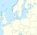 Map that could serve as a model as a request
 Time zone map of Greater Europe

 Lesser Antilles location map
 Base map
 Projection for California

 MIR payment system map
 Moscow boundaries need to be updated, they are outdated.
 Passante ferroviario di Milano
 Map of Naples Line 2 which runs on a part of the Passante.
 EU trading partners map
 Raster logo file
 Public transport map of Rio de Janeiro


 Highlighting is on wrong village
 English version
 French version

 Request taken. The style will be similar to other IUCN range maps M.Bitton (talk) 01:52, 19 December 2024 (UTC
 Done M.Bitton (talk) 10:32, 20 December 2024 (UTC)
 Thank you., En rouge (talk) 18:54, 29 December 2024 (UTC)
 7C2216 Muan airport crash enmap.svg
.svg)
.svg)